|
|
Geography of India
The geography of pre-independent India under British rule was very
different compared to present times. Earlier the nation was
administrated by British India and princely states existed that were
ruled by different individual rulers who were under the influence of
the then British Crown.
The British Empire of India expanded to regions of present-day
Bangladesh, Pakistan, India, Burma (Upper and Lower), Singapore and
Sri Lanka. The major provinces of this period included Burma, Bengal
(comprising of West Bengal, Odisha, Bihar and present-day
Bangladesh), Assam, Punjab, Bombay, Madras, Central provinces and
United Provinces. The minor provinces comprised of Ajmer-Merwara,
North-West Frontier province, Andaman and Nicobar Islands, Coorg and
British Baluchistan.
On gaining political freedom from the British, India experienced a
major divide or partition. It got divided into two nations, India
and Pakistan (1947). In 1905, there was a partition of Bengal
whereby Bengal got divided into East Bengal and West Bengal whereby
the former later on became East Pakistan and much later an
independent nation called Bangladesh. Punjab province also got
divided into Punjab (India) and Punjab (West Pakistan).
In the year 1950, India comprised of Governor�s states, Rajgramukh�s
states and Centrally Administered states. Some of these included
Jammu and Kashmir,
Punjab,
Rajasthan,
Uttar Pradesh,
Bihar, Vindhya Pradesh,
Bombay, Saurashtra, Hyderabad,
Manipur, Mysore, Travancore and others.
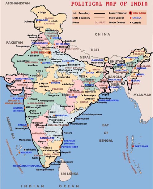
In the current scenario, India is declared to be a federal republic
comprising of 7 Union Territories and 28 states. There are almost
600 districts in the country which are further subdivided into
tehsils and finally into villages. The current states are
Andhra Pradesh,
Jharkhand,
Chhattisgarh,
Maharashtra,
Nagaland,
Uttar Pradesh,
West Bengal,
Arunachal
Pradesh, Goa,
Mizoram,
Punjab,
Tamil Nadu,
Uttarakhand,
Bihar,
Meghalaya,
Tripura,
Jammu and Kashmir,
Rajasthan,
Assam,
Himachal
Pradesh,
Madhya Pradesh, Gujarat,
Karnataka,
Kerala,
Sikkim,
Haryana,
Manipur and
Odisha.
The Union territories include the following:
The physical geography of India can be outlined as follows:
The Indo-Gangetic Plains of India
The Indus and the Ganga-Brahmaputra rivers comprise of the large
flood plains-The Indo Gangetic Plains. They are parallel to the
Himalayas, travelling from Jammu and Kashmir in the west to Assam in
the east, enriching and covering the states of Punjab, Haryana,
parts of Rajasthan, Uttar Pradesh, Bihar, Jharkhand and West Bengal.
The main water bodies of this area are the Ganges and Indus along
with its tributaries: Beas, Yamuna, Gomti, Ravi, Chambal, Sutlej and
Chenab.
Deserts of India
The main desert of India is the Thar Desert. It is the Great
Indian Desert that forms a significant portion of the western India.
It comes under four states namely Punjab, Haryana, Rajasthan and
Gujarat.
Highlands of India
The Highlands of India located centrally comprises of three main
plateaus such as the Malwa Plateau in the west, Deccan Plateau in
the south and the Chota Nagpur Plateau in Jharkand towards the east.
The Deccan Plateau is a triangular plateau, bordered by Vindhyas to
the north and covered by Eastern and Western Ghats. The sloping
nature of the plateaus gives rise to various peninsula rivers such
as the Godavari, the Krishna, The Kaveri and the Narmada. The Chota
Nagpur Plateau in the east covers Jharkand and is adjacent to parts
of Odisha , Bihar and Chhatisgarh. The Kathiawar Peninsula in
Gujarat is also a large peninsula of India.
East coast of India
The wide stretch of land between the Eastern Ghats and the Bay of
Bengal is the Eastern coastal Plain. It starts from Tamil Nadu in
the south to West Bengal in the north. The rivers in this area are
the Mahandi, Godavari, Kaveri and Krishna. The plains are divided
into six regions: the Mahanadi Delta, the southern part of Andhra
Pradesh, Krishna Godavari deltas, the Kanyakumari coast, Coromondel
coast and Sandy coastal.
West Coast of India
The narrow area of land between the Western Ghats and Arabian Sea is
the Western Coastal Plain. The plain sets off from Gujarat in the
north continuing till the states of Maharashtra, Goa, Karnataka and
Kerala. The rivers flowing into the sea are the Tapi, Narmada,
Mandovi and Zuari.
Islands of India
India�s two major offshore possessions of islands are the
Lakshadweep islands and the Andaman and Nicobar Islands. The union
territories govern both these islands. The Andaman and Nicobar
Islands consist of 572 isles that lie in the Bay of Bengal near the
Myanmar coast.
India�s most densely populated island is in Mumbai, Elephanta in
Bombay Harbour and Sriharikota Island in Andhra Pradesh.
Click on a specific state below to get geography of the
state.
|
|